Global maritime domain awareness and vessel analysis
ReleasesLearn about our latest improvements
Arming research analysts with hidden clues to their maritime domain
Global maritime domain awareness and vessel analysis
ReleasesLearn about our latest improvements
Arming research analysts with hidden clues to their maritime domain
Anomalous movements on a global scale
Case Study · 8 September 2022 · 5 minute read
Identifying, assessing and managing anomalous vessel movements with Starboard
Amongst the millions of ship positions, how can we find movements that are not normal? How can we find anomalous movements leading to the discovery of vessels that might be noteworthy and need further investigation?
When you have millions of data points everyday it is tempting to assume that applying advanced data science techniques, like machine learning, will be an ‘easy’ way to unlock your data’s hidden clues.
Throw it all in the hopper and see what anomalous movement comes out.
However, when it comes to automatic identification system (AIS) data–probably the largest available spatio-temporal database in the world–the challenges to make this ‘hopper’ work in a seamless and real-time way are substantial.
| What are these challenges with AIS data? |
There is no ground truthed set of anomalous behaviour for the model to learn from. Any model has to first learn what is normal and then work out what is not normal. Environmental conditions add variability. What is normal on a calm day and what is normal when the seas are rough can be quite different. Different types of vessels have very different normal movements. A cargo ship travels in defined routes, a fishing vessel does not. It is really messy data which can be missing or spoofed. AIS datasets don’t stay the same for long. Every minute, Starboard ingests 26,000 new AIS positions. It is multidimensional, so we need to consider both space and time in an operational model. |
Thankfully, the researchers behind GeoTrackNet 1 have discovered that the data wrangling challenges are not insurmountable and developed a model to uncover anomalous movements through all this complexity.
This work has provided the foundation for Starboard’s anomalous movement analysis and we have integrated the technique with our real-time AIS data and on a global scale.
Having these events displayed in Starboard means tools for assessing them, including vessel tracks and weather map layers, can instantly give users context.
Finding noteworthy activities faster
Providing users with a new lens for filtering vessels and defining noteworthy activity can help them to work through the vast amounts of maritime data.
For anyone with a vested interest in a particular vessel, or even fleet, they can monitor vessel movements globally to look for deviations to what would be the expected normal patterns.
For those working in border protection or maritime domain awareness, identifying a vessel with an anomalous movement might provide clues to unexpected or even potentially nefarious behaviour that were otherwise hidden.
| The GeoTrackNet Model |
GeoTrackNet is a maritime anomaly detector that uses probabilistic representation for AIS tracks and a contrario anomaly detection. It learns what is normal based on historical track movements and then flags any movement that is abnormal in relation to this. GeoTrackNet uses a variational recurrent neural network (VRNN), a machine learning algorithm, which is a particularly effective approach for probabilistic time series modelling. Instead of predicting a single value, as a typical neural network might, the output of the VRNN is a probability distribution. The model uses this to determine the probability of a vessel’s movements and position. Anomalous points are those with a probability less than a prescribed threshold. The final element is a geospatial a contrario detection. This allows for the probability thresholds to be regionalised so that there is not a single global threshold to define an anomalous movement. This provides sensitivity which gives the model added context for the varying activities seen in different geographic locations like transiting, port visits, or fishing. There is no ground truthed dataset for anomalous movement. This means that in order to assess the effectiveness of GeoTrackNet, it has been benchmarked against five other anomaly detection models. It performs well during this benchmarking and offers the benefits of anomaly detection for both geographic, course and speed related anomalies. The model is also able to accept additional spatio-temporal information which means in future it could take into account oceanographic information. GeoTrackNet has been developed by researchers at Collecte Localisation Satellites (CLS) and IMT Atlantique, who have offered this as an open source library to benefit those working in maritime domain awareness and vessel monitoring. Read the latest GeoTrackNet publication → |
Identifying vessels travelling an unusual route
To overcome issues with context and provide a global model, Starboard has applied the GeoTrackNet model using H3 cells 2. This means that what is normal within each cell is learned through the unsupervised model, and once this normal movement is known, abnormal movements can be flagged for that specific area of the world.
For those interested in shipping movements, understanding deviations from traditional routes can be useful for:
- Identifying the possibility that a ship’s captain may be deviating from the planned course.
- Comparing your fleet’s movements to those of others to understand if there is potential for route optimisation to support decarbonisation.
- Identifying vessels that might require further inspection when they arrive at your borders or transit through your area of interest.
| Tagging and alerting of noteworthy vessels for later inspection |
For those looking after an area of interest, or managing border security at sea ports, Starboard allows noteworthy vessels to be tagged for further investigation. When vessels are tagged, the tag is added to the vessel history at the current time and location of the vessel. The user who assigned the tag is also noted. This means tags can help manage processes like vessel assessments, inspection, and surveillance planning. Vessel managers can tag their fleet so they can review their movements in real-time at any point across the world. Users can also setup an alert so that if a noteworthy vessel enters their area of interest either they or others in their account can be notified. |
Finding vessels with unexpected manoeuvres
Anomaly detection in Starboard takes into account all four components of the spatio-temporal AIS data. Latitude, longitude, vessel position, and vessel speed. Smaller anomalous movements that might last less than an hour can be picked up by unexpected deceleration and orientation changes.
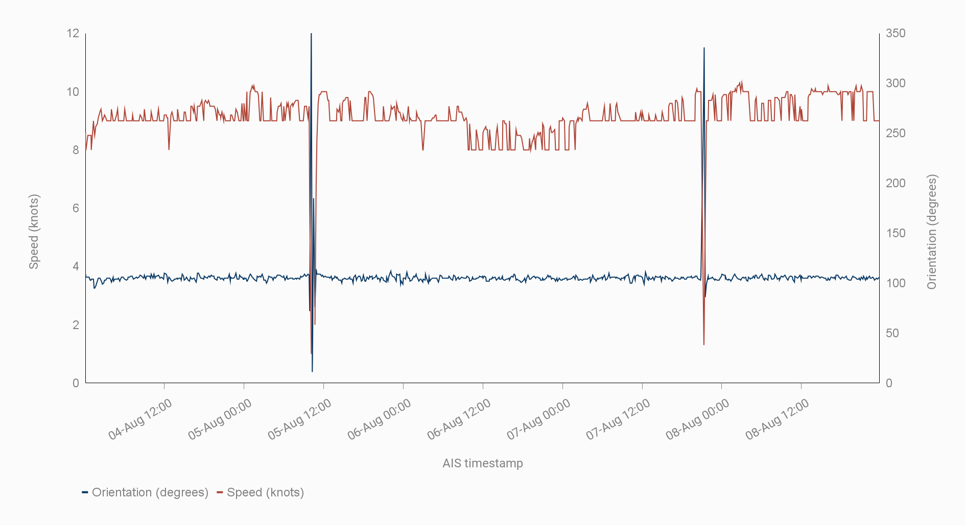
This vessel had two anomalous movements involving a deceleration and change of direction just a few days apart. Both lasted less than an hour. It is hypothesised that these looping movements in the open ocean are generally man overboard drills. However, in this case the duration and starting and ending position of the vessel are potentially not consistent with such a drill.
References
- Nguyen, Duong & Vadaine, Rodolphe & Hajduch, Guillaume & Garello, René & Fablet, Ronan. (2019). GeoTrackNet-A Maritime Anomaly Detector using Probabilistic Neural Network Representation of AIS Tracks and A Contrario Detection.
- H3 is an open source geospatial indexing system that partitions the world into hexagonal cells. https://h3geo.org/docs/
Get a demo
Anomalous movements is in beta testing and will be released soon. Get a demo to learn more about Starboard.
Read more

NEWS
Satellites used to search for illegal fishing in Tuvalu’s waters. Nearly 60 satellite scans of Tuvalu’s exclusive economic zone (EEZ) have been obtained since December 2021 as part of a pilot project under the World Bank-funded Pacific Islands Regional Oceanscape Program (PROP).
Read media release →
CUSTOMER CASE STUDY
Sabina Goldaracena is a custodian of the South West Atlantic maritime domain. She connects the clues in her investigations, uncovers hidden activity and works towards transparency by sharing her stories.
Read case study →
CASE STUDY
Using AIS vessel data to develop real-time risk assessments for efficient and safe vessel inspections
Read case study →
